Hiking Sabyinyo: Daring the Old Man's teeth
"Travel isn't always pretty. It isn't always comfortable. Sometimes it hurts, it even breaks your heart. But that's okay. The journey changes you - it should change you. It leaves marks on your memory, on your consciousness, on your heart and on your body. You take something with you.. Hopefully, you leave something good behind" ... Anthony Bourdain (fallen CNN "PartsUnknown" show host).
While Anthony was not specific in his statement, Adventure Travel is discomforting by default. This is true especially if one goes against forces of gravity and unforgiving altitude that pushes human physical ability to the limit.
Mgahinga National Park in South Western Uganda is adorned by three majestic volcanoes; Muhabura 4127m (the guide), Sabyinyo 3669m (Old Man's Teeth)and Gahinga 3474m (Pile of Stones). Sabyinyo cone comes second in elevation but it is technically the hardest to hike. Unlike Muhabura and Gahinga, Sabyinyo has three peaks; the first peak stands at a height of 3423 meters above sea level, the second peak conquers the sky at an elevation of 3537 meters and the third and highest peak at 3669meters.
Summiting all the three aforementioned peaks is absolutely physically demanding thus hiking Sabyinyo is utter "Daring of the Old Man's Teeth"!
From a distance, the volcano appears like teeth of an old man, this inspired the indigenous Bafumbira people to call it Sabyinyo.
With prior mental, physical and technical preparations, Hikers undergo briefing at Ntebeko (Headquarters of Mgahinga National Park) and then rally behind the allocated ranger guide.
http://nilepost.co.ug/2018/05/27/lone-explorer-rediscovers-feared-extinct-weaverbird/
The trail starts along the seasonal River Ntebeko and traverses the initial stretch of bamboo vegetation. The first one and half kilometers along the trail is a simple walk before the actual tussling against gravity starts. The trail crisscrosses elephant and forest buffalo trails thus stepping cautiously is vital to avoid sliding and wallowing in dung.
Elephant footprints in marshy areas along the trail create about half a meter deep holes that hikers need to avoid sinking-in. The hiking pace is based on the slowest and regular stops for a sip of water
come in handy.
Along the trail, nature presents her residents of all sorts; birds such as Rwenzori Turaco, Ravens, Crows and scarlet-tufted sunbird among many other species. One of the most iconic little vertebrate is the Rwenzori side-striped chameleon. They are built to survive at such an elevation with harsh climatic conditions.
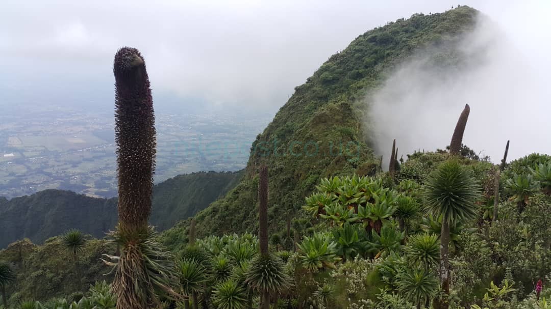
The ascent reveals unique vegetation types that only thrive at high altitude; Giant Lobelia, Scenario, Everlasting Flowers, Alchamira, Ericacious, Afroalpine Ericaceous Vegetation, Old Man's Bearded Trees and Red Hot Poker Flowers. One would think a piece of heaven fell at the sight of these amazing plants; it is a reward for those who dare the odds of gravity.
At a height of over 3000mabsl, the weather is erratic! Clouds descend and impede vision, the wind blows and clears the atmosphere in a blink. Clouds darken and suddenly a downpour but this may not last long
before another weather pattern conquers. It is a uniquely different world up there.
Making it to the first peak is akin to quarter finals of a football game, a number of people give up at this level and embark on a descent. At this stage a hiker takes a self-assessment whether to continue or not given the mercilessly steep nature of the second and third peaks. Getting to the second peak calls for descending the first peak and making it to the third and final peak requires getting to the base of the second peak.
At every level, guides allow for ample rest and refreshment. All limbs are at work when it comes to taking improvised ladders right from second to the third peak. These ladders get slippery given the misty/dewy condition of the elevation.
The ultimate prize and fulfilment is conquering the third peak at a height of 3669 meters above sea-level! Unlike Muhabura and Gahinga, the peaks of Sabyinyo do not have crater lakes. They are simply rocky tops with scanty mountain vegetation. Even more rewarding is the incredible feeling of being in three countries at the same time.
Borders of Uganda, Rwanda and Democratic Republic of Congo meet on the third peak of Sabyinyo. What a feeling! This elevation offers a panoramic view of about seven of the Virunga Volcanoes such as Karisimbi, Bisoke, and Nyiragongo among other cones. This can only be possible if the sky is clear.
Summiting Sabyinyo is one thing and making it back to the base is another. It is a descend and ascend affair putting a physical body to a cruel test. Mental strength at this level comes in handy and the zeal to return to the base plays a vital inspiration role. It gets better once the descent from the first peak ensues and the strenuous elevation ceases thus a mild walk to the base. The round trip distance covered for the entire hike is about 14 Kilometers.
Hiking Sabyinyo is the most challenging Day Hike in Uganda but the most rewarding of all! One needs to prepare for it because it demands for significant physical fitness. Some hikers experience altitude sickness and the unpredictable weather makes it even more challenging.
An intending hiker needs to have sufficient hiking gear such as boots, ponchos/rain gear, a light backpack, waterproof pants and walking sticks among requirements. One needs enough food and water to last a day in such an elevated jungle. It is recommendable to hire a porter for physical support as well as carrying
supplies/refreshments throughout the hike.
By Benedict Ntale (@ntaleh )
Mr Ntale is the founding manager of Apetreks Uganda (@apetreksug), a tour company.